|
DRAGSENS 1.01
Program Specifications
|
|
| Version: |
1.01
|
| Size: |
1.70 MB |
| Publisher: |
C. Killet Software Ing.-GbR |
| Date Added: |
Jan 8, 2011 |
| License [?]: |
Shareware (USD$750.00 to buy) |
| Operating System: |
Windows XP, Windows Vista, Windows NT, Windows ME, Windows 98, Windows 95, Windows 7, Windows 2003, Windows 2000 |
| Requirements: |
500MHz CPU, 500MB RAM, 100MB HD |
| Download Links: |
Download DRAGSENS
|
BumperSoft Editor's Review Status:
|
|
|
|
Publisher's Description of DRAGSENS
|
" GPS Position of a Dragged Sensor; Transformation and tracking. "
- From C. Killet Software Ing.-GbR
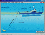
DRAGSENS is a geosoftware for the exact position estimation of a towed body, sensor, camera, array or net, dragged behind a ship, aircraft or vehicle, dragged underwater, at water, at earth surface or by airborne in real-time based on the location of a GPS-receiver.
DRAGSENS Geo Software is used for the exact position estimation of a towed body, sensor, camera, array or net, dragged behind a ship, aircraft or vehicle. The software allows a real-time estimation of the position of a dragged sensor based on the location of a GPS-receiver. The sensor thereby can be dragged underwater, at water or earth surface or by airborne. The software calculates the position of the sensor along the direction opposite to the course by compensation of the drift rate, the rolling and the cornering ability of the towing vehicle.
DRAGSENS receives current position data from a standard GPS string (RMC string). From these positions it averages a direction vector. Knowing the length of the tow cable, and the sensor depth, the sensor position is estimated and output in both kilometric and geographic formats. Suitable coefficients help keeping this estimation precise, considering, for example, the cable not as a straight line but as a parabolic arch.
DRAGSENS runs under Microsoft Windows and uses two independent serial ports. That also may be USB ports, controlled by a serial port driver. The input port receives the standard position data from the NMEA bus, while the output port gives the sensor position back in both geographic and kilometric format. Several strings with coordinates in different coordinate systems, date / time and additional information are broadcast on the second serial port. They all follow the NMEA standard for the RMC specifications including the checksum bit for transfer controlling.
This software at first was developed to add geo tags as an overlay with modern UTM coordinates on the footage taken by a towed underwater video camera. With suitable hardware the program delivers a video image, coming from a towed video camera, with the position as numeric overlay. It will also return the position of any towed sensor, including hydrophones, airguns, sonars or even nets. With minor modifications it could be used to estimate the position of objects on the ground during survey flights.
Limitations in downloadable version
Full functionality up to 200 GPS measures per program start.
|
Share DRAGSENS with Friends
Tags
|
RELATED DOWNLOADS
(Science and Engineering)
|
WEEK'S TOP DOWNLOADS
(All Categories)
|
|