|
Satellite Antenna Alignment 2.77.0
Program Specifications
|
|
| Version: |
2.77.0
|
| Size: |
924 KB |
| Publisher: |
AL-Software team |
| Date Added: |
Mar 17, 2011 |
| License [?]: |
Freeware |
| Operating System: |
Windows XP, Windows Vista, Windows NT, Windows ME, Windows 98, Windows 95, Windows 2003, Windows 2000 |
| Requirements: |
|
| Download Links: |
Download Satellite Antenna Alignment
|
BumperSoft Editor's Review Status:
|
|
|
|
Publisher's Description of Satellite Antenna Alignment
|
" Calculate the angles necessary for installing satellite dishes. Sun azimuth. "
- From AL-Software team
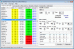
The program "Satellite Antenna Alignment" is used to calculate the angles necessary for installing satellite dishes. The main difference from similar software is the possibility to calculate the position for all satellites at once. Thus, you get a clear picture about what satellites can be physically visible from the location where the dish will be installed.
It should be kept in mind that the program makes a purely theoretical calculation according to formulas and in real circumstances a lot of additional factors should be taken into account when a satellite dish is installed. These factors include various obstacles (buildings, trees), the landscape, the altitude, transponder orientation, polarization, etc.
Nevertheless, this program will allow you to evaluate the position quite precisely. The calculation can be saved to a text file, copied to the Windows clipboard or printed out at once. It is possible to save the list of locations for which the calculation is done. Later on, you will not have to enter the coordinates of these locations again. Just select them from the table.
Additionally, the program has a mechanism for calculating the azimuth of the sun and you can do everything without a compass now!
Altitude (Elevation):
Altitude is the angle up from the horizon. Zero degrees altitude means exactly on your local horizon, and 90 degrees is "straight up". Hence, "directly underfoot" is -90 degrees altitude.
Azimuth:
Azimuth is the angle along the horizon, with zero degrees corresponding to North, and increasing in a clockwise fashion. Thus, 90 degrees is East, 180 degrees is South, and 270 degrees is West. Using these two angles, one can describe the apparent position of an object (such as the Sun at a given time).
Limitations in downloadable version
Free for private non-commercial usage.
|
Share Satellite Antenna Alignment with Friends
Tags
|
RELATED DOWNLOADS
(Science and Engineering)
|
WEEK'S TOP DOWNLOADS
(All Categories)
|
|