|
Earth Explorer DEM 3.5
Program Specifications
|
|
| Version: |
3.5
|
| Size: |
6.01 MB |
| Publisher: |
Motherplanet, Inc |
| Date Added: |
Sep 18, 2006 |
| License [?]: |
Shareware (USD$39.95 to buy) |
| Operating System: |
Windows XP, Windows NT, Windows ME, Windows 98, Windows 2000 |
| Requirements: |
|
| Download Links: |
Download Earth Explorer DEM
|
BumperSoft Editor's Review Status:
|
|
|
|
Publisher's Description of Earth Explorer DEM
|
" High resolution 3D interactive shaded relief topographic world map. "
- From Motherplanet, Inc
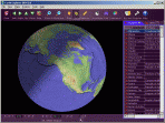
Earth Explorer DEM integrates high-resolution shaded relief topographic imagery (built from 1km resolution digital elevation model) with kinds of map layers such as political boundaries, coastlines, rivers, lake and island boundaries, 267 countries and regions, 40000+ ranked cities, 15000+ islands, and 1700+ noteworthy historical earthquakes since 1980 into a fantastic 3D earth globe. You can specify what kinds of map layers to be shown, rotate the globe, click right mouse button and pull/push to zoom in/out the current map view, measure distance between any two points on the map, etc.
Key features:
1. A 3D bird's-eye view of our beautiful earth;
2. Photo-realistic shaded relief topographic imagery at 1km resolution covered entire earth globe;
3. Integrates with several kinds of map layers:
Vector map layers:
a) Political boundaries (International boundaries and internal boundaries);
b) Coastlines, lakes, islands and rivers;
c) Longitude-latitude grids;
Point map layers:
a) 267 countries/regions and detailed information;
b) 40000+ ranked cities and information;
c) 15000+ Islands and information;
d) 1700+ noteworthy historical earthquakes since 1980 and detailed information;
4. Rotate/Zoom in/Zoom out functions lets you observe our beautiful planet at any point (Click right mouse button and pull/push to zoom in/out the current map);
5. Three kinds of operation modes (Drag, Center, Measure);
6. Measure distance between any two points on the globe;
7. Intelligent tips when your mouse moves upon a country/city/island/earthquake's mark or name label;
8. Sort country/city/island/earthquake table according to selected titles and interactive operate with the label and mark on the map;
9. Save favorite maps with BMP, JPEG formats;
With the newly redesigned interface and configuration utilities with the highest level of features and quality, Earth Explorer DEM works well under the Windows 98/ME/NT/2000/XP systems.
Limitations in downloadable version
30-day trial
|
Share Earth Explorer DEM with Friends
Tags
|
RELATED DOWNLOADS
(General Education)
|
WEEK'S TOP DOWNLOADS
(All Categories)
|
|